Set Of Bartholomew Road Maps In Leather Case


Set Of Bartholomew Road Maps In Leather Case
29856
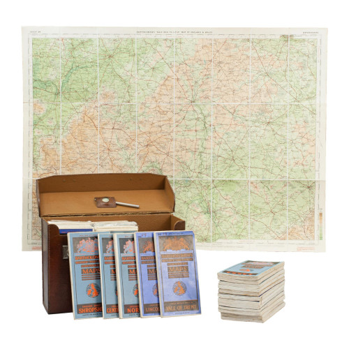
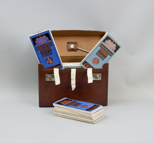
Vintage Set of Folding Bartholomew's Road Maps.
A set of 62 Bartholomew's Revised "Half-Inch" Contoured Maps of Great Britain in a hard leather travel case. Each map has its own sheet number, there is list on the inside of the lid stating the number and area of each map. Copyright John Bartholomew & Son Ltd., Edinburgh. The maps have a scale of 1 mile to half an inch. The set is complete with the case being in very good order with carry handle to the lid. The case embossed to the lid 'M.H.'.
Each map is made up of a single piece of printed paper mounted onto a linen sheet and they measure 86 cm wide & 59 cm high. The full set of maps comprises of:- 1/ Cornwall, 2/ Dartmoor, 3/ Exmoor, 4/ Dorset, 5/ New Forest, 6/ Sussex, 7/ North Somerset, 8/ Salisbury Plain, 9/ Surry, 10/ Kent, 11/ Pembroke, 12/ South Wales, 13/ Wye Valley, 14/ Oxford, 15/ Herts & Bucks, 16/ Essex, 17/ Cardigan, 18/ Vale Of Severn, 19/ Warwickshire, 20/ Cambridge, 21/ Suffolk, 22/ Mid-Wales, 23/ North Shropshire, 24/ Vale Of Trent, 25/ Fenland, 26/ Norfolk, 27/ North Wales, 28/ Merseyside, 29/ Peak District, 30/ Lincolnshire, 31/ North Lancashire, 32/ Wharfedale, 33/ S. Yorks & Humber, 34/ English Lakes, 35/ Teesdale, 36/ N. Yorkshire Coast, 37/ Galloway, 38/ The Solway, 39/ Tyneside, 40/ Ayrshire, 41/ Tweeddale, 42/ Northumberland, 43/ Islay & Kintyre, 44/ Firth Of Clyde, 45/ Mid-Scotland, 46/ Firth Of Forth, 47/ Argyll, 48/ Perthshire, 49/ Firth Of Tay, 50/ Arisaig & Lochaber, 51/ Grampians, 52/ Deeside, 53/ Uist & Barra, 54/ Skye & Wester Ross, 55/ Moray Firth, 56/ Buchan & Strathbogie, 57/ Harris & The Lews, 58/ Cape Wrath, 59/ Sutherland, 60/ Caithness, 61/ Orkney, 62/ Zetland.
Dimensions:
1950-1999
1960
Canvas
United Kingdom
Very good with normal wear and tear. Leather case with some rough corners.
RELATED ITEMS


